Getting the pulk…

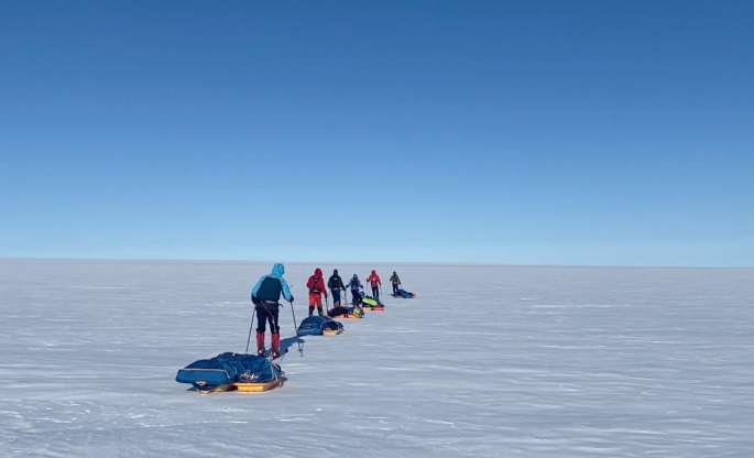
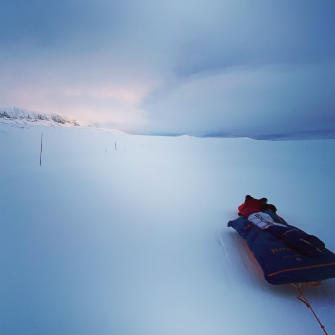
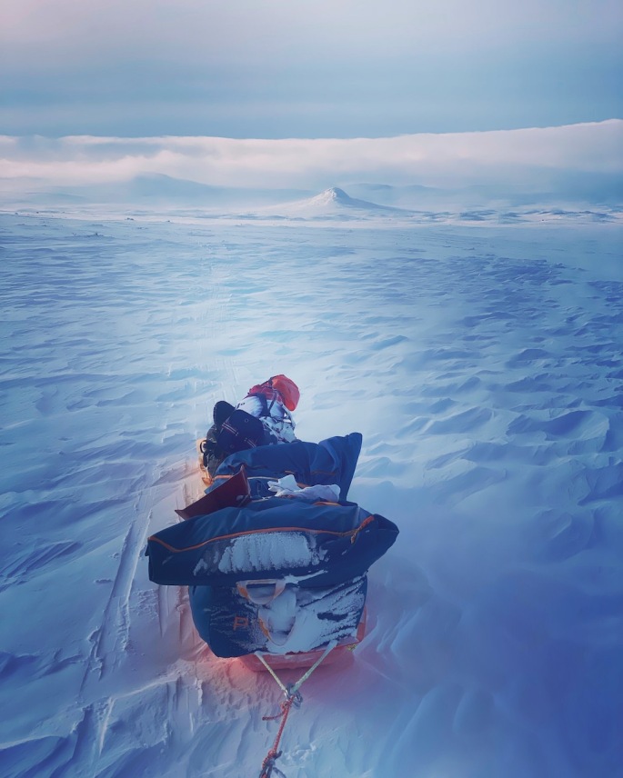
The pulk (the sled) is pretty important for the entire journey. I will be pulling all my food, tent and equipment, fuel and clothes it and at the start of the South Pole journey, it will weigh around 110kg or so. So it’s got to be pretty sturdy!

In Greenland, where we were pulling around 80kg or so, we used two Paris Pulks each. These are decent in that they are not very expensive, though as they are quite short, it was impossible to put everything onto just one of them. One of the big disadvantages of the Paris Pulks is that they are quite shallow and it is easy for them to become top-heavy and topple over to the side. You also have to have separate bags with all your gear and food that you secure on top of them with bungees or some other means. If you don’t pack your bag properly each morning, then you’ll be in for an annoying day having to go back and forth to the sled to turn it the right way up over and over again. Also, when the wind gets very strong, it can simply push the pulks over, and in Greenland we had to put the two pulks parallel with each other for a few days to stop that from happening.

Everyone on the Greenland expedition used Paris Pulks. You can see how say with the person at the back, the green bag that has the bedding is leaning over to the side. This happens a lot when you’re securing all the bags to the sled by the bungees, and it all affects the balance of the sled and how you move along.

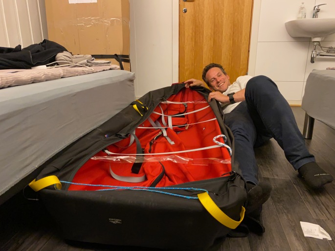
So for the South Pole journey, I have got myself a nice gigantic IceTrek Polyna sled. 210cm long, 68cm wide and 25cm deep (without the cover). Made by fantastically experienced polar explorer Eric Philips, they have a tremendous cargo volume and are designed to effectively float on soft snow and glide along nicely on the ice. Shouldn’t have any problems of overbalancing! I had arranged with Eric to pick the sled up in Svalbard (long story!)… quite an epic journey to get there and back… Inverness-London Luton–>London Heathrow-Oslo-Longyearbyen-Oslo-London Heathrow–>London Gatwick-Inverness… 6 planes, 6 different airports, 3 trains, 3 buses, 3 taxis, 2 days! Was kind of worried after collecting it that it might be too big for the airlines, and trying to cart it through the airport on the trolleys was pretty tricky given it’s length, but fortunately no real problems in the end! Tiring though.

Just a note: am (trying to!) raise funds for Cancer Research UK with these expeditions – please donate if you can, or share if you can’t!!! It would be amazing to have your support!

Traveling through whiteouts

Some of the most intense days when skiing on the Hardangervidda plateau were spent skiing through whiteout conditions. Whiteouts are when you can’t tell the difference between the snow beneath your skis and the sky. Whiteouts are not necessarily blizzards, and indeed, blizzards are often incorrectly called whiteouts. More often you will be travelling over the snow through fog or cloud. You might be able to see dark objects like rocks in the terrain, but that will be about it. Travelling through a whiteout is like travelling through limbo: you feel like you are moving yet going nowhere. Nothing seems to change. There are no shadows and there is no contrast. It can be disorientating and strangely claustrophobic at the same time. If you’re not prepared, it can be dangerous, no matter where you are.

Skiing through such conditions can be tricky enough even on flat snow as navigation becomes much harder. If you are lucky, there will be some rocks, and you can use them to help with the navigating, though these can easily disappear from view, behind a small hill or in even denser cloud. The rocks can be deceptive as well as you have no sense of scale; they might be small rocks close to you or larger rocks further away. There could easily be a few small hills or large snowdrifts between you and the rocks as well, but you won’t know until you reach them because they are covered in snow so are indistinguishable from anything else. You will need your compass and GPS – even better if you got a compass mount so you can have the compass extended in front of you without having to hold it in your hands, so you can constantly see your heading. Failing that, if there is wind, you will feel the direction from which it is coming in general. Then you can use that as a navigational support: if you’re heading north and you have an easterly wind, for example, keep it so it’s hitting you from the right.

Going up or downhill, or across sastrugi where the wind has cut through the snow to create those amazing ice sculptures beneath your feet, is even trickier. Especially with an 80kg sled behind you. Yes, you will have your compass and GPS, and you will know your general heading. But the maps will only show so much; the contours will most likely measure 20 metre differences in the terrain but nothing more detailed. Snowdrifts and slight dips and small mounds aren’t shown and you can’t keep looking at your GPS anyway, especially as battery is a consideration. Even when armed with your heading, any undulations through the snow will be invisible. It is impossible to see where the snow is steepest and work out the best route up. You might be struggling up a steep climb one moment, inching your way up, but then you suddenly come to a dip in the snow and before you know it, you are skiing down into a small dip. Maybe a frozen rock pool or hidden stream beneath the snow or some other feature. And your sled hurtling down the slope behind you…

I found myself slowly zig-zagging my way up and down the hillsides, especially with the sled being pretty heavy. Keep calm and keep breathing. Judge the feeling of the snow beneath the skis, the pull of the sled on the harness getting heavier and lighter as the terrain changed. The general balance and feel. It was slow, often painful, and challenging–especially when the snow got really deep–and there were points when it just seemed the climb would never end; going into that endless white void.

But then it gets flat again and you realize that the hardest parts are behind you and that you managed it. And you keep going.

Norway training Part 2: Preparing for Greenland and South Pole

With the ending of the group training with Hvitserk, I took the opportunity to go on my own solo journey around the Ustaoset and Finse region, and up to the Hardangervidda Plateau. With the South Pole plans at the end of the year, I aim to travel solo, so I need to have as much experience out by myself as possible. The journey to the Pole is not just physical, it’s also psychological – travelling alone for around 50 days, in the most extreme conditions, pulling the heavy weight of the pulk the entire time; the routine… every day, getting up, breakfast; packing up the sleeping bag and tent… skiing for the next eight hours or so… pitching the tent again; firing up the stoves and heating the water for food. Dinner and then sleep. And repeat. With nobody else around; just the satellite phone and locator beacon as your only means to contact the outside world a thousand miles away.

The Hardangervidda Plateau is a tremendous place to train. While the terrain is different from Antarctica – you have to ski through mountain passes and the wind is quite variable – the conditions can be formidable. I had a couple of storms with winds reaching around 70mph or so, and plenty of days with just constant strong headwinds. Then there were the whiteouts (I will write a separate post about them as you can say so much!!!), and travelling through deep snow, going up to your knees even with skis on that are meant to distribute your weight… and the climbing… It was tough! At the same time, with the tough conditions, Norway is wonderful because there is such great infrastructure. UT.no is a superb site that shows all the winter and summer trails (not in English, but it is easy to work out), and it also shows cabins where you can stay. You can use the site to easily plan out the routes you would like to take. From around early February people go out on their snow-mobiles to mark out the trails with long thin branches plugged into the snow as well, which would help anyone out there. The cabins were not open when I was there but if you join the DNT – like the backpackers association in the country (their website is also in English) – they give you a key that you can use to access the cabins in emergencies.

The second night out, I made a mistake with the tent in incredibly strong winds which led to some of the poles breaking… it was stupid of me, but I know what I did wrong and after repairing everything, it was nice for the confidence to be able to put the tent up again in similar conditions with no problem. Still hard when by yourself… so much harder than when with other people… but it’s something that I will have to deal with constantly in Antarctica. I won’t be able to just stay in the tent when it is windy – the winds will be merciless there! So ultimately, it was good to make the mistake in Norway where I could mend things and recover, to keep going. And ultimately, learn from what happened. It was a great feeling to arrive at Finse at the end of the time on the plateau having been able to work, navigate and travel through all those conditions, and it certainly helped build the confidence enough to know that with continued training, I’ll be able to manage on Antarctica. Exciting just to think about!!

To Braeriach

The route from Coylumbridge, just outside Aviemore, to Braeriah

One of the more productive things that I managed to do when I was stuck in the isolation of the lockdown in New Delhi was actually, over the period of five months, write a first draft of a novel I had been thinking about for sometime. Was pretty pleased with myself – you know when you have lots of ideas but they don’t connect? Well, I managed to work out how to bring them together within a nice structure and the writing just kept on flowing. The reason I mention this is that one of the chapters is based up in the Highlands, and specifically the Angels Ridge and the second highest mountain in Scotland, Braeriach. One of the reasons I wanted to train in the Cairngorms, and more specifically, start from Aviemore, was that Braeriach is less than a day’s hike from the town, and I wanted to see how accurate my descriptions were considering I had never been there and had been relying on the photographs of others and Google Maps to try and gauge what it might be like.

Towards the Lairig Ghru. Ben Macdui–the second highest mountain, just a few metres taller than Braeriach, can be seen ahead, while Braeriach, which is just across the glen, is obscured by the trees on the right

It didn’t disappoint and was a tremendous start to the next few days of hiking. My rucksack was ridiculously heavy, laden with plenty of supplies, though part of the whole challenge was also to cope with the weight on my back! The first 10km were pretty flat, easy and again in perfect clear conditions. Walking along a forested path that gradually opened out to just heather and to reveal the mountains of the Lairig Ghru, including Braeriach, before me. Even had more chance to mess around with the drone. But once the ascent started… wow! The next 5km up from 600m to almost 1,300m. Tiring and, on the steeper parts, painful! Plenty of other hikers passed me on the trail as I just slowly made my way up, and there were so many false summits before finally making it.

I had originally aimed to go around 25km to get to the bottom of the Angel’s Ridge, near Devil’s Point, but by the time I got to the summit, after around 16-17km, I was getting a bit tired and it was getting a little late so decided to pitch the tent just a little further along next to the Wells of Dee – the source of the River Dee, which flows through to the sea at Aberdeen, where I was born. Thought there was some nice poetry there! Nice to finally be out in the tent as well, and it definitely was worth it just for the chapter.

What a year!

So, it’s been a long while since have written anything, though as with pretty much everyone, the plans from the last year or so have been massively affected by everything that has been happening in the world. The planned Greenland expedition got put off from 2020… with the hope to manage in May 2021, though for obvious reasons with the continued pandemic and vaccination just starting to get going, the journey is now planned for May 2022. Fingers crossed it will happen!

With the pandemic and the current apocalypse as a global backdrop, in March 2020, I fell sick with pneumonia, which meant that March was a complete write-off as I was hospitalised and unable to do any training for a while. I think that even had there been no pandemic and subsequent restrictions (though they did not test me for COVID as it was at the time when testing was severely limited), I wouldn’t have been able to manage the journey in May 2020 as it took me a long time for to get back on my feet again.

To cut a long story short though, I am now back living in the UK and managing to sort out training within the confines of the lockdowns. Think that being over here will make the training easier to manage to be honest, especially once the restrictions ease, so I think the year ahead will be quite exciting. Already just being able to go out for daily hikes and runs (and continuing with the pilates!) is a huge difference from the New Delhi, where the smog and the heat could be overwhelming!

Also there might be news on a future South Pole expedition, but that’s still in the works… but here’s hoping!

Functional pilates…

New Delhi is not the best place in the world to train for an expedition in the arctic environment. It’s a busy, bustling and pretty crazy city that is difficult to walk around and while there are parks littered throughout, the air quality is far from the best in the world (amongst the worst ten places in the world, and frequently at the top of the list, especially in winter when farmers burn crop stubble and cold air keeps the smoke trapped over the city). So it was a nice bonus finding Vesna’s Alto Celo pilates studio where Vesna and her husband Anuraag Jacob, together with a few other teachers, provide one-on-one pilates coaching… and not just pilates… After telling them about the expedition, they are helping me with more functional training focused on developing my core, and muscles that I will be using to pull the 80kg sled across the Greenland ice-cap. Can be tiring though started to real feel the difference after a few sessions, so after a couple of months going now.

Welcome to my blog!

Thanks for visiting this site! Over the next few weeks and months I will be updating it with news about my training for the forthcoming Greenland Expedition (and training in New Delhi where we are already getting temperatures in the 20s, when Greenland will be -30C or so… isn’t the easiest thing to think about!), and other adventure-related news. If you yourself are planning any adventures, I would love to hear from you! I always love chatting about such journeys, and if I can help you in anyway with your preparation, I would be delighted!

I hope you find it interesting and that you can follow me – of course, if you are able to donate to Cancer Research to support my cause of raising funds for them, that would be wonderful! But if not, no worries – It would be fantastic if you could follow, share, or even just visit occasionally!